Continental Divide
This is a vague term, and it’s not a single thing. You can speak of a continental divide, not the continental divide.
In most contexts, it refers to a hydrological divide, which is a point where water flows to different oceans. This means that most continents will have a north-south divide and an east-west divide, depending on what “side” of the continent you’re talking about draining water to.
But it gets a little more confusing, because sometimes water drains into vallies of basins, so there might be “intra-continental divides.”
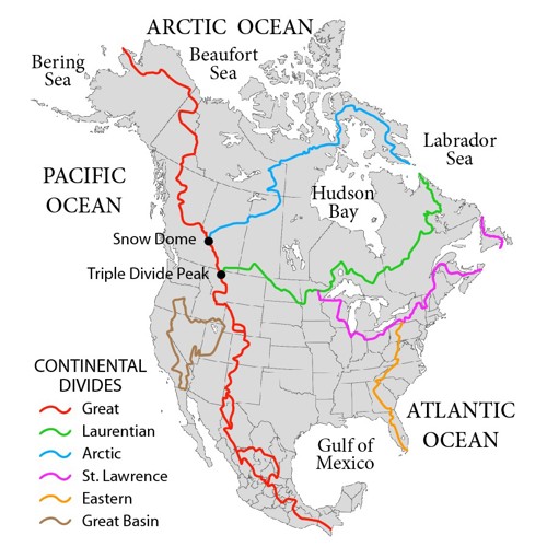
Here’s the graphic used to illustrate the Wikipedia article:

Credit to Wikipedia user Pfly
In North America, the major ones are:
The Great Continental Divide which runs north-south, from Alaska, though British Columbia, then down through Great Plains and Rockies of the United States into Mexico. Generally speaking, water to the west of this flows to the Pacific, water to the east flows to the Atlantic.
The Laurentian Continental Divide, which runs east-west from the Canadian border above Montana, across the Great Plains and Midwest states, then up into Canada again. It splits into the St. Lawrence divide which runs through New England. Generally speaking, water to the north of these flow to the Hudson Bay, water to the south of these flows to the Gulf of Mexico.
Why I Looked It Up
Annie and I were driving to Northern Minnesota, and we passed a sign on I-29 that said “Continental Divide.” It’s somewhere around the border between North and South Dakota.
I couldn’t figure out what it was referring to. Turns out this is the Laurentian Divide.
In addition to the interstate sign, there’s an entire pullout with a historical marker on Highway 28 to the east of the interstate. It’s here.