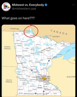
Northwest Angle

This is a geographic “notch” of Minnesota that pokes up into Canada. It contains the northernmost point in the contiguous United States.
What’s unique about this place is that it mostly consists of the Lake of the Words in the southern portion, which cross the entire span, from east to west.
At the north, there’s a patch of land. Most of this land is the Northwest Angle State Forest, but there are some homes there as well, and about 100 people, living on United States soil.
This geography means that the people living here (Americans) have no land border with their own country. Their only land border is with Canada to the west. To get to American soil, they would have to enter Manitoba and cross Canadian land, or take a boat across the Lake of the Woods to the south.
I did some checking in Google Maps, and it would be about an hour’s driving time from the land border with Canada down to Longworth, Minnesota, which, as near as I can tell, would be the most obvious route across the border.
I tried to calculate “boat time,” but I couldn’t find any human structures along the shore (it’s a national forest), so there was no obvious place to start.
Why I Looked It Up
A friend posted the above meme to Facebook, with the area circled, asking: “What goes on here?”
I decided to find out what goes on there.