Great Circle Route
In geometry, a “great circle” is a flat plane that cuts through the middle of a sphere. Essentially, it becomes the longer line that was drawn around that sphere.
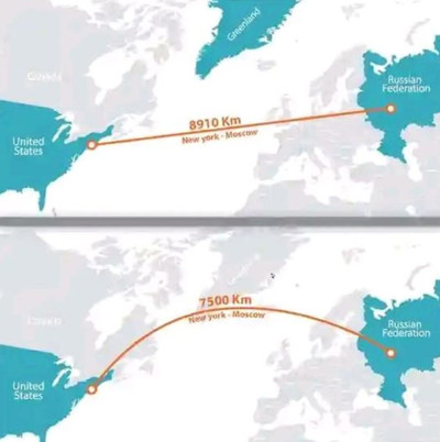
In aviation navigation, a “great circle route” is the shortest path between two points, and is achieved by finding the great circle that both points are on. This is invariably an arc, not a straight line.
Indeed, “straight” doesn’t mean much when talking about a sphere, because the entire surface is curved – nothing on a sphere is “straight.” When looking at it overlaid on a sphere, the great circle route actually looks fairly straight. It only appears to be a curved line or arc when flattened to a Mercator projection map. (See image on this page.)
The great circle routes are why flights between the U.S. and Europe arc up and over the arctic circle, rather that going directly east or west.
Why I Looked It Up
Great circle routes were a plot point in Reamde.
Terrorists had access to a private jet in Xiamen, China, and were trying to figure out how to get it into North America. From Xiamen, they can’t fly a great circle route to Toronto, because it takes them over China, North Korea, and Siberia. What they can do is plot a great circle route to Calgary, which takes them just off the coast of Asia. They ended up somewhere north of Idaho after having gone over the north pole.
Also, I remember flying from Paris to Los Angeles once. On the in-flight map, I saw that we flew distinctly southwest through Canada and entered the United States in northern Montana.
Update
Added on
I found this image on a social media post showing the difference in mileage on a route from New York to Moscow when traveled “straight” (really meaning around) as opposed to a great circle route. Basically, the top route only looks “straight” because the map is flat – it loses the context that you would be traveling in a half-circle, like the front of a human’s beltline.
